
Ready, Set, Curb!
Alexandra Stote
Objective:
Can your team reduce the earth’s greenhouse gas emissions to zero by the year 2050? Working together, you must answer team challenges and link climate impacts to greenhouse gas emissions in order to help sequester, or remove, greenhouse gases from the atmosphere. The game ends in the year 2050, and the goal is to remove all greenhouse gases by the time you get there! But be careful, some cards and actions require you to add greenhouse gases along the way. How close to zero emissions can your team get by 2050? Good luck!
Required Materials:
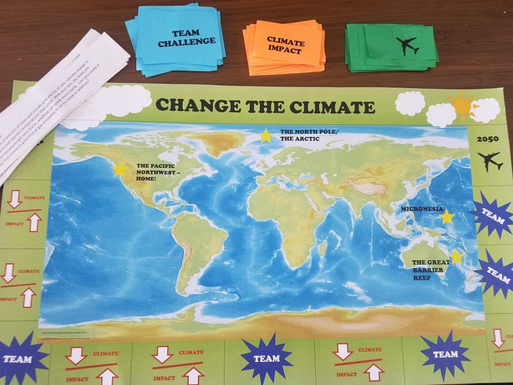
- Game Board (MS) (HS)
- Three Types of Playing Cards (“Climate Impact (MS)(HS) ,” “Team Challenge (MS)(HS) ,” and “Impact Pathway (MS)(HS) ”)
- Dice
- Twenty Paperclips
- Bucket
- Game documents (editable versions available at the end of this chapter.)
- Facilitators Guiding Questions (HS) (MS)
- Student Guide (HS) (MS)
- A vocabulary list for students and teachers (adapted from EPA 2013)
Setting up:
The game starts with 20 paper clips in a bucket in the middle. The bucket represents the earth’s atmosphere, and the paper clips represent carbon emissions. The goal is to remove all paper clips by the end of the game, which represents achieving zero emissions by the year 2050.
Each player should start with 5 “Climate Impact Pathways” (airplane cards) in their hand and should have their own game piece on the starting line. You only need to start with these cards.
Sort the different cards face down in different piles before beginning.
Description of different cards:
“Climate Impact”: These cards are just like “chance” in monopoly. They tell you what actions to take, and they affect the atmosphere either positively or negatively.
“Team Challenge”: These cards challenge your team to collectively think of a solution to the problem presented to you on the card.
“Climate Impact Pathways” (Airplane symbol): Whenever you land on an airplane, you will have a chance to construct a “climate impact pathway” from the cards with the airplane on the back. The ecosystems (described in High School Student Guide) each tell a different story of how climate change is affecting those regions, giving you clues about how an increase in greenhouse gases leads to the climate impact that ecosystem is experiencing. Using the clues, the students will have to put together a full “climate impact pathway” to trace the climate impact back to greenhouse gases. Examples of these scenarios are given in Facilitators Guiding Questions.
Game Play:
Everyone starts at the first square. Take turns rolling the die and moving around the board. The square you land on tells you which action to take (described below). Keep playing until every player reaches 2050 and try to get as close to zero paper clips as possible!
Whenever you pick up a card, read it out loud to your team.
When you land on a “Climate Impact” square, it could be good or bad for the environment. Read the card and find out!
When you land on a “Team Challenge” square, you have the chance to remove greenhouse gases from the atmosphere if you work together and find a solution to the challenge presented on the card. Teamwork makes the dream work!
When you land on a square with an airplane, you have the chance to unlock a climate pathway. This means that you can fly to any ecosystem on the board that is labeled. Each ecosystem is described in the “Guiding document for students” to give you an idea about how climate change is impacting that ecosystem. Once you fly to the ecosystem, you can construct a “climate impact pathway” using the airplane cards in your hand. The pathway must connect that ecosystem to climate change in some way. For example: If you choose to go to the Great Barrier Reef, and you know that corals are threatened by climate change, you can use your cards to put together a linkage that looks something like this: Greenhouse gases→ Ocean temperatures warming→ Coral bleaching. The point is to create a pathway that illustrates the climate impact in that specific region. Do you want to visit a specific ecosystem but you don’t have the right cards to put together a full pathway? That’s okay! You can trade your airplane cards with anyone who wants to trade with you.
When you fly to an ecosystem, you must deposit a paperclip in the bucket because flying is one of the biggest contributors to greenhouse gas emissions. However, if you successfully put together a climate impact pathway during your visit there, you may remove as many paper clips as linkages you’ve made. For instance, in the Great Barrier Reef example I gave above, you could remove 3 paper clips because I linked 3 items. The longer the pathways, the more emissions you can remove!
After you visit an ecosystem and construct a climate impact pathway, you can return to the square you started on to keep playing. Pick up as many airplane cards as you put down so that you still have 5 airplane cards in your hand.
Rules:
- You can only construct one climate impact pathway per ecosystem per game.
- Other players can help you construct the pathways– this is a team game after all!
- Remember to deposit one paper clip when you fly and remove the same number as the linkages you’ve made.
- Don’t be afraid to share ideas during the team challenge! The more feedback the better.
The future lies in your hands– it’s time to turn back the clock on climate change!
Middle School Student Guide:
MICRONESIA
Micronesia is an area in the Pacific Ocean that is made up of thousands of islands. Over half a million people live on the coasts. Many people make a living by fishing or by working in tourism, such as diving. Sea levels have risen by eight inches on average in the last 150 years, which leads to homes flooding and forces people to move. What leads to sea-level rise, and how does sea level rise impact animals or people? Can you create a climate impact pathway that connects greenhouse gas emissions to sea level rise and impacts on humans?
THE GREAT BARRIER REEF
The Great Barrier Reef is the longest coral reef in the world (1400 miles long!) and is located off the coast of Australia. Coral reefs are home to fish, turtles, sharks, and other kinds of marine life. Corals are tiny animals that are very sensitive to water temperature. They turn white when the water is too warm, and if they stay white for too long, they will die. If the corals die, this is also bad for the creatures that depend on reefs for survival and for people who like to go diving on the reef. Can you create a climate impact pathway that connects greenhouse gas emissions to corals dying and impacts on other animals?
THE NORTH POLE/THE ARCTIC
The Arctic is at the North Pole. It is home to land and marine animals who depend on the ice to survive. Polar bears stand on the ice while they hunt for their favorite food– seals. Ice in the North Pole is melting because the temperature of the earth and the water is getting warmer. If the ice melts too much, the polar bears won’t be able to hunt, so they won’t be able to eat. Can you create a climate impact pathway that connects greenhouse gas emissions to ice melting and impacts on animals?
THE PACIFIC NORTHWEST– HOME!
The area that we live in has lots of and lots of trees and usually gets plenty of rain. Climate change is causing less rainfall in this area and warmer temperatures than usual. With less rain, the trees are getting drier, and when temperatures get very warm, wildfires can spark more easily. Can you create a climate impact pathway that connects greenhouse gas emissions to an increase in wildfires?
Middle School Facilitators Guiding Questions:
Description of different cards:
“Climate Impact”: These cards are just like “chance” in monopoly. They tell the students what actions to take, and they affect the “atmosphere” (greenhouse gas deposits) either positively or negatively
“Team Challenge”: These cards challenge the team to collectively think of a solution to the problem presented to them on the card
“Climate Impact Pathways”: At the end of the game, the students will have to choose one ecosystem out of the four options (Arctic, Micronesia, Great Barrier Reef or the Pacific Northwest) and connect a “climate impact pathway.” The ecosystems each tell a different story of how climate change is affecting those regions, giving the students clues about how an increase in greenhouse gases leads to the climate impact that ecosystem is experiencing. Using the clues, the students will have to put together a full “climate impact pathway” to trace the climate impact back to greenhouse gases. Examples of these scenarios are given below. Note: students will have the descriptions of each of the ecosystems, but they won’t have the guiding questions or the examples that are shown in bullets. The guiding questions and the examples below are for the facilitators to help guide the discussion in groups.
MICRONESIA
Micronesia is an area in the Pacific Ocean that is made up of thousands of islands. Over half a million people live on the coasts. Many people make a living by fishing or by working in tourism, such as diving. Sea levels have risen by eight inches on average in the last 150 years, which leads to homes flooding and forces people to move.
- What leads to sea-level rise? Hint: it could be something happening in another part of the worl (i.e. sea ice melting)
- How does sea level rise impact animals or people?
- Example of a climate impact pathway: Greenhouse gases→ Earth temps warming→ Sea ice melting→ Sea levels rising→ Habitat loss/Threat to homes and people/Increased risk of floods/Threat to tourism
GREAT BARRIER REEF
The Great Barrier Reef is the longest coral reef in the world (1400 miles long!) and is located off the coast of Australia. Coral reefs are home to fish, turtles, sharks, and other kinds of marine life. Corals are tiny animals that are very sensitive to water temperature. They turn white when the water is too warm, and if they stay white for too long, they will die. This process is called “coral bleaching” because the corals turn white. If the corals die, this is also bad for the creatures that depend on the reefs for survival and for people who like to go diving on the reef.
- What factors led to corals turning white and dying (i.e. coral bleaching)?
- What are some future impacts if corals don’t recover from “bleaching” or turning white?
- Can you trace warming water temperatures back to greenhouse gases?
- How does corals dying affect other animals?
- How does corals dying affect people?
- Example of a climate impact pathway: Greenhouse gases→ Earth temps warming→ Ocean temps warming→ Coral bleaching→ Habitat loss/Threat to tourism/Harder to find food (for the animals that live on the reef)
ARCTIC
The Arctic is at the North Pole. It is home to land and marine animals who depend on the ice to survive. Polar bears stand on the ice while they hunt for their favorite food– seals. Ice in the North Pole is melting because the temperature of the earth and of the water is getting warmer. If the ice melts too much, the polar bears won’t be able to hunt, so they won’t be able to eat.
- What factors of climate change make it more difficult for polar bears to hunt?
- What will eventually happen if polar bears can’t find enough food?
- Example of a climate impact pathway: Greenhouse gases→ Earth temps warming→ Sea ice melting→ Habitat loss/Harder to find food
Pacific Northwest– HOME!
The area that we live in has lots of and lots of trees and usually gets plenty of rain. Climate change is causing less rainfall in this area and warmer temperatures than usual. With less rain, the trees are getting drier, and when temperatures get very warm, wildfires can spark more easily.
- What causes wildfires?
- How does climate change contribute to wildfires?
- Example of a climate impact pathway: Greenhouse gases→ Earth temps warming→ Ground gets drier→ Trees get drier→ Wildfires can happen more easily→ Habitat loss/Threat to homes and peopl3
High School Student Guide:
MICRONESIA
Micronesia is an area in the Pacific Ocean that is made up of thousands of islands, including the islands of Palau, Kiribati, and Guam. Over half a million people live on the islands in homes close to the shoreline. Many people make a living by fishing or by working in the tourism industry. Since 1870, sea levels have risen by eight inches on average and have already started to displace families and flood homes. What factors led to sea-level rise, and what are some potential future impacts if sea levels keep rising?
THE GREAT BARRIER REEF
The Great Barrier Reef is the longest living structure on earth (over 1400 miles!) along the eastern coast of Australia. Coral reefs support diverse communities of fish, turtles, sharks, and other marine life because they provide shelter and food for various species. In 2017, the Great Barrier Reef experienced two of the largest coral bleaching events in history. Coral bleaching happens when the coral (which are live animals!) expel the tiny colored organisms that live on them, which is what makes the coral turn white. If the coral stays white for a while, it will eventually die, which is bad news for the creatures that depend on the reefs for survival and for people who enjoy exploring the reefs. What factors led to coral bleaching, and what are some potential future impacts if corals don’t recover from bleaching? Alternatively, can you think of another climate impact pathway that would lead to coral bleaching?
THE ATLANTIC OCEAN
The Atlantic Ocean supports countless fisheries including lobster, black sea bass, bluefish, and blue crab. Like humans, fish are sensitive to temperature, and can get too hot or too cold when the temperature increases or decreases. If the fish are uncomfortable for an extended period of time, they might start to look for new waters to live where the temperature is more comfortable for them. If the fish move far away, this creates problems for fishermen, who rely on catching these fish in a certain area. With no fish around, there’s nothing to catch! Trace the climate impact pathway that leads to this disruption of fishing patterns. Can you think of another impact of changing fish migrations?
THE EVERGLADES
Coastlines are the parts of land that are closest to the ocean, and are therefore usually very close to sea level, or at “low elevation”. The Everglades in Florida are one example of a low elevation coastline. The Everglades also represent an estuarine wetland habitat, which is an area where freshwater near the coast mixes with saltwater from the ocean that washes up with the tides. This unique interaction supports a special variety of life that depends on this mixing. How can changes in the ocean affect this unique habitat? What climate impact pathway leads to those changes?
THE AMAZON
The massive Amazon rainforest spreads across 8 South American countries and is home to the greatest biodiversity on the planet. The vastness of the forest represents one of the largest carbon “sinks,” or carbon storage, in the world. Can you think of a pathway that would decrease the Amazon’s ability to store carbon (hint: think of what makes the Amazon a forest)? What other effect(s) would that pathway have?
THE HIMALAYAS
The highest mountain range in the world supports animals that are especially adapted to cold temperatures, such as the snow leopard. Warming temperatures in high altitude lead to melting snow and warmer climates. Snow leopards, which have adapted to live in cooler temperatures, are especially vulnerable to these shifts. Seeking colder weather, snow leopards continue to migrate north to find weather that is more suitable for them to live in. They have already disappeared from places they used to live because the habitat is no longer suitable. Trace the climate impact pathway that has led to snow leopards leading north. How has this migration affected the lives of snow leopards?
THE ARCTIC
The northernmost part of the globe, the Arctic, is home to terrestrial and marine animals who depend on the ice for their daily activities. Recently, polar bears who rely on the ice as platforms for hunting their favorite source of food, seals, have had an increasingly difficult time hunting. If polar bears continue to have difficulty finding enough food for themselves and their cubs, they will face an even greater danger of becoming extinct. Can you trace the climate impact pathway that may be making it more difficult for polar bears to hunt?
CITIES
Over one half of the world’s population lives in cities or urban environments. Cities are impacted by climate change in different ways. Cities on the coast can be at-risk of sea-level rise, while cities that are inland can be at risk of drought or intense heat waves. Many cities are trying to adapt to or mitigate the effects of climate change. Can you think of a climate impact pathway in cities that either shows how cities might contribute to climate change (think of factories, or maybe lots of traffic), OR a pathway that shows how people who live in cities might be affected by climate change?
SAHARA DESERT
The Sahara Desert is the largest and driest desert on earth. In the face of climate change, these conditions are becoming even more extreme and leading to the expansion of the Sahara Desert, a process known as desertification. What is a possible climate impact pathway that could be expanding the area of the Sahara, and what are some human or animal impacts from desertification?
CALIFORNIA– HOME!
The area that we live in has lots of trees and gets plenty of sunshine. Climate change is causing less rainfall in this area and warmer temperatures than usual. With less rain, the trees are getting drier, and when temperatures get very warm, wildfires can spark more easily. Can you create a climate impact pathway that connects greenhouse gas emissions to problems we are already experiencing due to a changing climate?
OR— THE PACIFIC NORTHWEST– HOME!
The area that we live in has lots of and lots of trees and usually gets plenty of rain. Climate change is causing less rainfall in this area and warmer temperatures than usual. With less rain, the trees are getting drier, and when temperatures get very warm, wildfires can spark more easily. Can you create a climate impact pathway that connects greenhouse gas emissions to an increase in wildfires?
High School Facilitators Guiding Questions:
Description of different cards:
“Climate Impact”: These cards are just like “chance” in monopoly. They tell the students what actions to take, and they affect the “atmosphere” (greenhouse gas deposits) either positively or negatively
“Team Challenge”: These cards challenge the team to collectively think of a solution to the problem presented to them on the card
“Climate Impact Pathways”: At the end of the game, the students will have to choose one ecosystem out of the four options (Arctic, Micronesia, Great Barrier Reef or the Pacific Northwest) and connect a “climate impact pathway.” The ecosystems each tell a different story of how climate change is affecting those regions, giving the students clues about how an increase in greenhouse gases leads to the climate impact that ecosystem is experiencing. Using the clues, the students will have to put together a full “climate impact pathway” to trace the climate impact back to greenhouse gases. Examples of these scenarios are given below. Note: students will have the descriptions of each of the ecosystems, but they won’t have the guiding questions or the examples that are shown in bullets. The guiding questions and the examples below are for the facilitators to help guide the discussion about how climate impacts will differ depending on region.
MICRONESIA
Micronesia is an area in the Pacific Ocean that is made up of thousands of islands. Over half a million people live on the coasts. Many people make a living by fishing or by working in tourism, such as diving. Sea levels have risen by eight inches on average in the last 150 years, which leads to homes flooding and forces people to move.
- What leads to sea-level rise? Hint: it could be something happening in another part of the world (i.e. sea ice melting)
- How does sea level rise impact animals or people?
- Example of a climate impact pathway: Greenhouse gases→ Earth temps warming→ Sea ice melting→ Sea levels rising→ Habitat loss/Threat to homes and people/Increased risk of floods/Threat to tourism
GREAT BARRIER REEF
The Great Barrier Reef is the longest coral reef in the world (1400 miles long!) and is located off the coast of Australia. Coral reefs are home to fish, turtles, sharks, and other kinds of marine life. Corals are tiny animals that are very sensitive to water temperature. They turn white when the water is too warm, and if they stay white for too long, they will die. This process is called “coral bleaching” because the corals turn white. If the corals die, this is also bad for the creatures that depend on the reefs for survival and for people who like to go diving on the reef.
- What factors led to corals turning white and dying (i.e. coral bleaching)?
- What are some future impacts if corals don’t recover from “bleaching” or turning white?
- Can you trace warming water temperatures back to greenhouse gases?
- How does corals dying affect other animals?
- How does corals dying affect people?
- Example of a climate impact pathway: Greenhouse gases→ Earth temps warming→ Ocean temps warming→ Coral bleaching→ Habitat loss/Threat to tourism/Harder to find food (for the animals that live on the reef)
THE ATLANTIC OCEAN
The Atlantic Ocean supports countless fisheries including lobster, black sea bass, bluefish, and blue crab. Like humans, fish are sensitive to temperature, and can get too hot or too cold when the temperature increases or decreases. If the fish are uncomfortable for an extended period of time, they might start to look for new waters to live where the temperature is more comfortable for them. If the fish move far away, this creates problems for fishermen, who rely on catching these fish in a certain area. With no fish around, there’s nothing to catch! Trace the climate impact pathway that leads to this disruption of fishing patterns. Can you think of another impact of changing fish migrations?
- How can warming ocean temperatures lead to migration?
- How could the fish migrating affect people?
- How could the fish migrating affect other animals? (hint: think about changes in food availability and predator/prey relationships)
- Example of a climate impact pathway: Greenhouse gases→ Earth temps warming→ Ocean temps warming→ Habitat loss→ Habitat loss/Threat to tourism/[Create your own impact]
THE EVERGLADES
Coastlines are the parts of land that are closest to the ocean, and are therefore usually very close to sea level, or at “low elevation”. The Everglades in Florida are one example of a low elevation coastline. The Everglades also represent an estuarine wetland habitat, which is an area where freshwater near the coast mixes with saltwater from the ocean that washes up with the tides. This unique interaction supports a special variety of life that depends on this mixing. How can changes in the ocean affect this unique habitat? What climate impact pathway leads to those changes?
- This is a challenging one, but an opportunity to talk about how sea level rise can affect wetlands through a process called “desalination.” As ocean water mixes with freshwater in the wetlands, animals and plants that depend on the freshwater will be negatively affected by the introduction of salt water to their communities.
- Example of a climate impact pathway: Greenhouse gases→ Earth temps warming→ Sea level rising→ Habitat loss→ [Create your own impact]
THE AMAZON
The massive Amazon rainforest spreads across 8 South American countries and is home to the greatest biodiversity on the planet. The vastness of the forest represents one of the largest carbon “sinks,” or carbon storage, in the world. Can you think of a pathway that would decrease the Amazon’s ability to store carbon (hint: think of what makes the Amazon a forest)? What other effect(s) would that pathway have?
- How does cutting down trees add more greenhouse gas emissions to the atmosphere? (Hint: think about the carbon that was stored in the trees).
- This is another challenging ecosystem that is meant to help students think about how the loss of carbon “sinks” will contribute to climate change by releasing greenhouse gases that have traditionally been stored for a long time.
- Example of a climate impact pathway: Deforestation → Greenhouse gases OR Habitat loss→ (can connect either to impacts to people and animals in the area or even in other parts of the world)
THE HIMALAYAS
The highest mountain range in the world supports animals that are especially adapted to cold temperatures, such as the snow leopard. Warming temperatures in high altitude lead to melting snow and warmer climates. Snow leopards, which have adapted to live in cooler temperatures, are especially vulnerable to these shifts. Seeking colder weather, snow leopards continue to migrate north to find weather that is more suitable for them to live in. They have already disappeared from places they used to live because the habitat is no longer suitable. Trace the climate impact pathway that has led to snow leopards leading north. How has this migration affected the lives of snow leopards?
- The snow leopard trajectory is pretty straightforward. This example can also be used to talk about reduced snowpack in regions that are used to seeing snow.
- How can warmer temperatures at higher altitudes affect the seasons? (Hint: migration patterns and food availability!)
- What does warmer temperatures in the mountains mean for the snow that’s there? What does that mean for the water supply that billions of people rely on?
- Example of a climate impact pathway: Greenhouse gases→ Earth temps warming→ Shift in suitable habitat for animals/ Habitat loss/Harder for animals to find food
THE ARCTIC
The northernmost part of the globe, the Arctic, is home to terrestrial and marine animals who depend on the ice for their daily activities. Recently, polar bears who rely on the ice as platforms for hunting their favorite source of food, seals, have had an increasingly difficult time hunting. If polar bears continue to have difficulty finding enough food for themselves and their cubs, they will face an even greater danger of becoming extinct. Can you trace the climate impact pathway that may be making it more difficult for polar bears to hunt?
- What factors of climate change make it more difficult for polar bears to hunt?
- What will eventually happen if polar bears can’t find enough food?
- Example of a climate impact pathway: Greenhouse gases→ Earth temps warming→ Sea ice melting→ Habitat loss/Harder to find food
CITIES
Over one half of the world’s population lives in cities or urban environments. Cities are impacted by climate change in different ways. Cities on the coast can be at-risk of sea-level rise, while cities that are inland can be at risk of drought or intense heat waves. Many cities are trying to adapt to or mitigate the effects of climate change. Can you think of a climate impact pathway in cities that either shows how cities might contribute to climate change (think of factories, or maybe lots of traffic), OR a pathway that shows how people who live in cities might be affected by climate change?
- This one is best used with “create your own” cards so that students can link development to the emission of greenhouse gases. Some examples include: more traffic, more housing, more building, etc.
- Example of a climate impact pathway: Create your own→ Greenhouse gases → Earth temps warming→ Increase in air pollution
SAHARA DESERT
The Sahara Desert is the largest and driest desert on earth. In the face of climate change, these conditions are becoming even more extreme and leading to the expansion of the Sahara Desert, a process known as desertification. What is a possible climate impact pathway that could be expanding the area of the Sahara, and what are some human or animal impacts from desertification?
- What do you think will happen when the driest place on earth gets even drier?
- What impact will that have on animals, people, food, and water?
- Example of a climate impact pathway: Greenhouse gases→ Earth temps warming→ Lack of water/drought conditions → / Habitat loss/Harder for animals to find food
CALIFORNIA– HOME!
The area that we live in has lots of trees and gets plenty of sunshine. Climate change is causing less rainfall in this area and warmer temperatures than usual. With less rain, the trees are getting drier, and when temperatures get very warm, wildfires can spark more easily. Can you create a climate impact pathway that connects greenhouse gas emissions to problems we are already experiencing due to a changing climate?
- What causes wildfires?
- How does climate change contribute to wildfires?
- Example of a climate impact pathway: Greenhouse gases→ Earth temps warming→ Ground gets drier→ Trees get drier→ Wildfires can happen more easily→ Habitat loss/Threat to homes and people
OR
Pacific Northwest– HOME!
The area that we live in has lots of and lots of trees and usually gets plenty of rain. Climate change is causing less rainfall in this area and warmer temperatures than usual. With less rain, the trees are getting drier, and when temperatures get very warm, wildfires can spark more easily.
- What causes wildfires?
- How does climate change contribute to wildfires?
- Example of a climate impact pathway: Greenhouse gases→ Earth temps warming→ Ground gets drier→ Trees get drier→ Wildfires can happen more easily→ Habitat loss/Threat to homes and people
Vocabulary:
Climate: The average weather conditions in a particular location or region at a particular time of the year. Climate is usually measured over a period of 30 years or more.*
Atmosphere: the layer of gases that surrounds the earth and separates us from space
Climate change: A very big change in the Earth’s climate. The Earth is currently getting warmer because people are adding greenhouse gases to the atmosphere that trap heat. “Global warming” refers to warmer temperatures, while “climate change” refers to the broader set of changes that go along with warmer temperatures, including changes in weather patterns, the oceans, ice and snow, and ecosystems around the world.*
Greenhouse gases: Greenhouse gases are natural or man-made gases that trap heat in the atmosphere and contribute to the greenhouse effect. Two examples of greenhouse gases are carbon dioxide and methane.*
Methane: a type of greenhouse gas
Carbon dioxide: a type of greenhouse gas. People are adding carbon dioxide into the atmosphere, mostly by burning fossil fuels such as coal, oil, and natural gas.*
Weather vs. climate: Weather is what happens on any certain day, but climate is the pattern of weather over years and decades
Emissions: When a gas (such as carbon dioxide) is released into the air or atmosphere.*
Carbon footprint: The total amount of greenhouse gases that are emitted into the atmosphere each year by a person, family, building, organization, or company.*
Energy: The ability to do work. Energy comes in many forms, such as heat, light, motion, and electricity. Most of the world’s energy comes from burning fossil fuels to produce heat, which can then be converted into other forms of energy, such as motion (for example, driving a car).*
Renewable energy: A natural resource that can be produced, regrown, or reused fast enough to keep up with how quickly it is used. Wind, tides, and solar energy, for example, are in no danger of running out and can be consumed by people almost forever!*
Wind farm: an area where lots of windmills are placed to collect energy from the wind. This is a type of renewable energy!
Fossil fuels: types of energy that releases bad greenhouse gases when they’re burned
Diesel gas: a type of gas that powers ships and trucks. This comes from fossil fuels and releases bad greenhouse gases when it’s burned
Pollution: something harmful or destructive that is introduced into the environment. For example, plastic and greenhouse gases are both considered types of pollution because they’re harmful for the environment.
Produce: to make
Reduce: to lower; the opposite of increase
Reusable: something that can be used again and again
Recycle: To collect and re-process, or reuse, a material so it can be used again to make a new product.*
Increase: to go up; more of something; to get bigger; the opposite of reduce
Community: a group of people who all share similar characteristics and face similar challenges. For example, a city, a neighborhood, or a class can all be considered a community.
Policy: an action or decision that is enforced to try to solve a problem or make something better. A policy can be made by a government, a business or any community of people.
Ecosystem: an area where plants and animals live together in one system; the weather, climate, and environment are the same for everything that lives there.* Example: a rainforest, or a desert, or a tropical coral reef
Habitat: The place or environment where a plant or animal lives and grows.*
Coral bleaching: When corals turn white because they are unhealthy. One way this can happen is if the water temperature is too warm. Corals that remain white, or “bleached” for a long time will eventually die.
