
14 The Little Boy and the Sea
El Niño/Southern Oscillation (ENSO) is perhaps the clearest example of the interconnected nature of the Earth’s climate. When the oceans warm in the tropical Pacific, signaling the beginning of an El Niño event, weather systems around the whole world respond. From Greenland to the Red Sea to the blue glaciers of Antarctica, El Niño carves its imprint across the globe. It steers the paths of mighty tropical cyclones, distorts the powerful jet streams, and shuts down life-giving monsoons. All of this change is in response to a disruption of ocean currents in a relatively small area of the world.
Fishermen on the coast of Peru in the late 1800s noticed that every few years, around Christmas time, the normally cold ocean would turn warm. They called the warm ocean current “El Niño,” literally meaning “the little boy” but referring to the Christ child, since the current would often peak in late December. The phenomenon is locked to the seasonal cycle, but this does not imply ease of predictability.
El Niño causes more variation of the Earth’s climate than anything other than the seasonal cycle, which drives the massive differences between summer and winter. But while the whole world is adapted to the beat of the seasons, El Niño is irregular enough that it still takes us by surprise. The seasonal cycle is exact in its rhythm, from solstice to equinox in perfect time. It is like a John Philip Sousa march, with steady, even beats that set the marching speed for the entire world. You can set your watch, or more precisely, your calendar, to it.
In comparison, El Niño is the cymbal of a free jazz drummer, who uses the mighty crash only in highly irregular patterns. Sometimes the drummer strikes it with such force that the reverberation completely drowns out the rest of the band, while other times just a soft touch seems to suffice. The drummer ignores the cymbal for many measures, then it reemerges like no pause happened. A pattern seems to appear, but just when the audience thinks they have figured it out, the crashes mutate and lose all sense of rhythm. El Niño sometimes waits for just a year to reappear, while at other times its stays dormant for a decade.
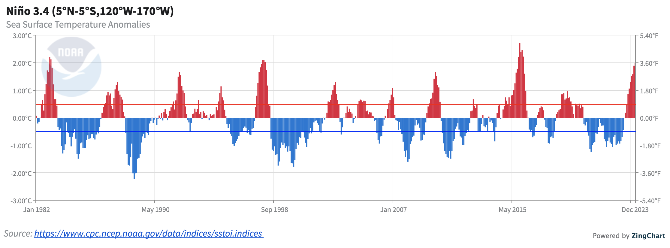
Sea surface temperature anomalies in the Niño 3.4 region, calculated from NCEI.
The unpredictability of El Niño is largely because it can organize quite rapidly. The little boy can appear seemingly out of nowhere, organizing itself into a globe-changing monster in just a matter of months. In order to understand the fickle nature of El Niño, one must go to the source, the waters on the west coast of South America, where these events are centered.
A Fountain from the Depths
Even though it is located only a few hundred miles from the equator, the water in Paita, Peru is downright frigid. Even in summer, water temperatures barely exceed 20o C in a normal year. Miami Beach, which is over 1000 km from the equator, has warmer water even in the dead of winter. The average ocean temperature in Paita is 18o C, similar to coastal North Carolina and cooler than the annual average everywhere in the Gulf of Mexico. By comparison, in the Solomon Islands on the other side of the Pacific Ocean, the ocean temperature averages nearly 30o C.
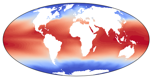
Time average sea surface temperature (COBE).
One might think that marine life would avoid the chilly waters of Peru in the otherwise balmy tropics. But in fact these cold waters harbor one of the most vibrant ecosystems in the world. It is not the coldness of the water that attracts the sea life, but rather the ocean currents in the region that provide the basis of the habitat. The frigid Humboldt Current, or Peru Current, flows northward along the coast of South America. Within this current, cold water flows upward from the depths in a phenomenon known as upwelling. Deep ocean waters are near freezing, so it is this upwelling that causes the cold temperatures off the coast of Peru.
Upwelling is caused by sustained winds that blow across the ocean in a specific pattern. Any gust of wind applies a stress on the surface seawater, causing waves to form, and this can create steadier currents as well. On certain parts of the planet, breezes blow in ways that essentially part the seas, creating ocean currents that flow in opposite directions away from each other. Due to strong influence of the Coriolis force on Earth, Ekman transport is the primary response to a wind stress, causing transport 90 degrees to the right of the wind in the Northern Hemisphere and 90 degrees to the left of the wind in the Southern Hemisphere.
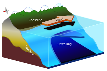
Upwelling can occur, for instance, due to northerly winds along the west coast of North American, which cause Ekman transport to the west, away from the coast. Waters rise from the depths to conserve mass.
Along the equator, there is a specific type of upwelling that occurs with easterlies winds. North of the equator, the Ekman balance between wind stress and the Coriolis force causes transport of ocean water to the right, or northward, in response to easterly wind stress. South of the equator, the same stress causes ocean water to move to the left, or southward, in response to easterly wind stress. Thus equatorially upwelling occurs, since surface currents part on either side of the equator.
The Case of the Missing Sardines
Upwelling also brings up nutrients that support rich marine ecosystems. Near the surface of the ocean, living things deplete nutrient concentrations, while water below is rich in substances like nitrogen and phosphorus that plants need to grow. Upwelling replenishes the surface ecosystem with fresh fertilizer. Plankton and seaweed thrive within these fountains from the depths that upwelling provides, making these regions the rainforests of the ocean, teeming with life. Upwelling regions cover only 1% of the globe, but 50% of the world’s commercial fish are caught there.
The seawater that rises from the depths along the coast of Peru has not seen sunlight for several hundred years. The water has slowly drifted through the dark depths where nary a ray of light reaches. The deep ocean is known to scientists as the abyss, from the Greek for “bottomless.” It is cold and dark, far from any warmth or illumination, which only penetrates the first few hundred feet in the ocean. The upwelling deep water rising to the surface in the Humboldt Current at present has followed a circuitous path around the world, slowly inching through the abyss for many decades, while the world above harnessed electricity and industrialized. When the first rays of light finally shine upon this ancient water, it comes alive, celebrating its return to the overworld by supporting massive blooms of sea plants and huge schools of fish.
Phytoplankton grow particularly bountifully in the upwelling of the Humboldt Current, and these microscopic plants form the base of a rich food chain. Small fish called Peruvian anchovies, or anchoveta, feast on the plankton, and the waters teem with them. The little fish are big business. The Peruvian anchovy fishery is one of the most valuable in the world. More fish are caught there than in the entire United States; it constitutes 10% of the entire world’s fish harvest of any species. Believe it or not, not all of the 6 million metric tonnes per year of anchovies go on pizzas or into Caesar salads. The Peruvian anchovy is actually more sardine sized and is not the same species as what is commonly sold as anchovies. The catch is primarily made into fishmeal, which provides a cheap protein source for farmed fish or livestock, or into fish oil, a dietary supplement that has increased rapidly in popularity.
Perhaps even more surprising than the size of the Peruvian anchovy catch is its volatility. The fishery has seen extreme ups and downs, even from one year to the next. Much of the variability is driven by El Niño. For instance, during the 1997-98 El Niño event, only one-fourth of the normal catch was recorded. After the 1982-83 El Niño, the fishery was completely shut down. More than 50,000 people in the fishing industry lost their jobs after the El Niño of 1972-73, which along with overfishing, led to a collapse of the fishery that took years to rebound.
El Niño has devastating consequences on the ecosystem because these events are associated with a reduction of upwelling. Nutrients are no longer brought up from depth, so the plankton disappear, as do the fish. The shutdown of upwelling also eliminates the source of the cold waters. The frigid flow from the abyss is no more, so the eastern equatorial Pacific warms substantially during El Niño. The warmth of the ocean water in the eastern Pacific is the defining characteristic of El Niño, and is also key in driving rainfall patterns nearby.
The UW Atmos Outreach video team created this multipart detective story about the role of El Niño in sardine production. Check it out below!
Making it Rain
Northwest Peru is usually a desert, receiving only a few inches of rain per year on average. The town of Chulucanas in the foothills of the Andes normally receives only 8.5 inches of rain during the rainy season, but during the 1982-83 El Niño, it received over 13 feet of rainfall. Across the normally barren landscape, vegetation grew rapidly and shallow lakes formed. Grasshoppers feasted on the new plants and multiplied rapidly, approaching plague-like abundances. Toads took up residence in the lakes, feasting on the grasshoppers. The usually quiet desert resonated with life, as the deafening mating calls of all these new creatures rang out across the countryside.
The high rainfall in Peru during El Niño is a direct result of the intense warming of the nearby ocean. Similarly, the usually cold ocean causes coastal Peru to be a desert during normal years. Warm ocean water is favorable for precipitation because it provides the two ingredients that are required for rainfall: 1) humidity in the air and 2) rising air currents, since hot air rises.
Not all locations experience such impressive deluges during El Niño. Large swaths of the tropics like Indonesia, southeast Asia, and northern Australia, instead have a paucity of precipitation. The reason for this complex and important climate connection is actually quite simple. Consider the old saw “what goes up must come down.” If air rises and it is rainy in one place, there must be sinking and dryness in another region. This simple idea is the most essential reason that the tropics are interconnected, during El Niño and otherwise. When there is rising air over Peru, there must be sinking motion, and suppressed rainfall, elsewhere. Of course, when sinking air occurs over populated regions, it often brings catastrophic drought.
A Dance of Wind and Sea
Much of the beauty of El Niño from a scientist’s perspective is the cooperation of the atmosphere and the ocean. Each event involves an interplay of the sea and the wind, with the ocean driving changes in the atmosphere, and the winds causing movement of the ocean. Away from the equator, where the ocean response to winds is strongly influenced by the Coriolis force, the (Ekman) transport is perpendicular to the wind than along with the wind. But in the close vicinity of the equator, water responds quite directly to wind forcing.
El Niño is centered exactly on top of the equator, which turns out to be the perfect place on Earth for close coupling between atmosphere and ocean. The lack of Coriolis force at the equator means the ocean moves in the same direction as the winds. When winds blow from east to west, as they do over much of the tropics, the ocean responds by flowing towards the west. Water piles up against the coast of Indonesia, causing sea levels to be significantly higher there. The water in the west Pacific is typically about a foot and a half higher than in the east Pacific. Warm water gathers below the surface as well, with increased thermocline depth, so near Indonesia there is a deep slab of warm water. Scientists call this feature the Western Pacific warm pool.
The easterly winds that flow throughout the tropics are called the trade winds. The trade winds provided a quick route for ships to cross from Europe to the New World, and from the west coast of North America to Asia. Mariners long ago realized that to catch the trades from Europe, they needed to head south towards the tropics. The trade winds cause most of the weather in the tropics to blow in from the east instead of the west, like in more temperate locations. Across the Pacific, the easterlies are especially strong, with an additional source, a set of wind currents called the Walker circulation. The Walker circulation ends up playing a fundamental role in determining the lifecycle of El Niño events.
During El Niño, the winds abruptly slacken, and the warmth that is normally submerged in the Western Pacific warm pool spreads dramatically across the Pacific, exactly on the equator. The dramatic birth of an El Niño event moves so rapidly only because of a remarkable cooperation between ocean and winds. The ocean does not simply respond passively to winds; it steers the atmosphere as well.
Under normal conditions, the warmest water in the world ocean is in the “warm pool” off the coast of Indonesia, while the eastern Pacific is 10 degrees Celsius colder. Upward motion and rainfall tend to occur over the warmest ocean temperatures, so the warm pool is also one of the rainiest spots on Earth, anchored by steadily rising air currents. To feed the rising motion, air flows in from the east Pacific and from the Indian Ocean, creating circulation cells. This strengthens the easterly winds that blow across the Pacific. Jacob Bjerknes named this the Walker circulation in his famous El Niño paper, in honor of Gilbert Walker’s discovery of the Southern Oscillation, the atmospheric phenomenon that essentially represents changes in strength of the Walker circulation.
Warm water in the west Pacific warm pool helps set up a strong Walker circulation, which causes vigorous easterly winds to blow across the Pacific. But the winds cause the warm water to be there in the first place, by piling up warm water to the west, and deepening the thermocline there. The normal state of the equatorial Pacific Ocean is self-sustaining, strengthening itself in place. Atmosphere and ocean reinforce each other, causing a stronger circulation than would exist with wind or sea alone. But what happens when the balance is disturbed?
Consider an initial warming of the east Pacific. In response, rising motion and rainfall develops, shifting the rainfall maximum towards the central Pacific instead of over the west Pacific warm pool. This causes a weakening of the Walker circulation, and of the easterly winds across the Pacific. Since there are no longer strong winds to keep the warm pool in the west Pacific, warm water sloshes eastward. Along with this, the pool of warm water above the thermocline becomes shallower in the west Pacific. Upwelling decreases in the east part of the ocean, leading to rapid temperature increases. El Niño has arrived!
When an El Niño event is set in motion, the ocean changes a little, causing the atmosphere to respond, which then causes a larger change in the ocean. The cycle repeats, and the changes become larger and larger. El Niño is a positive feedback cycle because an initial whisper of El Niño is strongly amplified by oceanic and atmospheric processes, leading to rapid transitions. The amplification process is called the Bjerknes feedback, in honor of its esteemed discoverer. Because of the Bjerknes feedback, the onset of El Niño can be extremely rapid. For instance, before the record-setting 1997-98 El Niño, the first real sign that an event was imminent was only about 4 months before its appearance.
Since El Niño events are characterized by warm water in the central and east Pacific, heavy rainfall appears in those normally dry areas. The west coast of South America, Mexico, and the southern United States all experience high rainfall as well, often accompanied by flooding. The western Pacific becomes parched, as places like Indonesia, Australia, and India suffer large rainfall deficits, along with famine and forest fire in extreme cases. The Walker circulation, normally an intense flow of air, can slow to a snail’s pace during strong El Niño events. Upwelling in the ocean shuts down in response to the weakened Walker circulation, devastating the marine ecosystems.
The slope of the ocean surface flattens quite substantially during El Nino. During the 1982-83 El Niño, the ocean surface in the east Pacific rose by 30 cm, while the west Pacific fell by a similar amount. The sea level drop near Indonesia was so extreme that the tops of coral reefs were exposed to the open air, where the direct sunlight caused them to bleach. The entire deep slug of water in the west Pacific thins and spreads out eastward during El Niño. This causes there to be much more warm water at the surface during El Niño, as water that is normally below the ocean surface is revealed. In response, the temperature of the entire Earth is higher during El Niño. In 1998, the strongest-ever El Niño gave the Earth a fever, and temperatures rose considerably compared with the surrounding years. 1998 remained the warmest on record until 2005, despite there being significant global warming away from the tropical Pacific in the intervening seven years. Global temperature records set in the late 2010s were particularly impressive because they occurred without a strong El Niño.
Why La Niña?
While El Niño events tend to be the most severe, the opposite phase in the oscillation can also have violent implications. Essentially the opposite impacts are felt during these events: Indonesia and Australia flood, while South America and southern North America experience drought. Scientists began studying these phenomena as well, often referring to them as “anti-El Niño” events in scientific papers. Of course, since El Niño originally referred to the Christ child, this name literally means… the anti-Christ! A terminology without the satanic implication was adopted, “La Niña,” meaning the little girl.
It took a respected but also culturally aware scientist to recognize that the original term needed to be abandoned. George Philander, a South African climatologist, is the scientist who coined the term “La Niña.” Philander was born in South Africa in 1942, son of one of the most famous poets of the Afrikaans language. Philander immediately showed great talent for mathematics and science, but he almost was not given a chance to make use of his skills. He was admitted into University of Cape Town in the last year that people of color were allowed. It is harrowing to think of what the field of tropical climatology would have been like without the contributions of Philander, and of how many other brilliant minds in South Africa were not given a chance to excel during apartheid.
After gaining his degree in applied mathematics, Philander and his family moved to the United States when more apartheid laws were enacted. Philander enrolled in Harvard University for graduate school. He spent most of his career in Princeton, New Jersey, both at the university and at the Geophysical Fluid Dynamics Laboratory, a government lab focused on climate prediction. Philander made brilliant contributions to the mathematical theory of tropical oceanography and to the development of state-of-the-art computer models of the ocean. His book Our Affair with El Niño is required reading for anyone interested in learning more on the subject.
I had the privilege of studying under Philander during graduate school for a semester. His upbringing was steeped in literature and the arts, which influenced him throughout his career, and showed in his lectures and everyday life. He was frequently seen bounding off to the music department to play concertos on the piano. Philander is a talented painter as well. He would host phenomenal departmental gatherings at his home, which was filled with objets d’art, and musical offerings were always an important part of these fêtes.
Philander’s research helped put Bjerknes’ feedback on better quantitative grounds. He also made progress on the problem of how the ocean shifts from one state to another, and why El Niño and La Niña events occur when they do. Key in the transitions and the predictability of El Niño are massive-scale waves in the ocean that bring warmth across the mighty Pacific. These waves also help determine how the tiny eastern Pacific ends up affecting weather across the planet during El Niño.
The Thousand Mile Wave
If you drop a pebble in a pond, ripples appear and spread away from the initial splash in ever-expanding circles. These concentric circles are little waves, with alternating crests and troughs just like the swells that move through the open ocean. The waves help communicate to the rest of the pond that there was a disturbance nearby. A frog on a lily pad a few feet away from the initial splash might receive notice of the event within a second, when waves pass through and jar the pad up and down. A leaf floating a few yards away might feel a smaller lurch a few seconds later. Since waves move equally in all directions, in perfect circles, the time it takes for the signal to arrive only depends on the distance away.
Now imagine a strange pond, in which ripples do not follow the normal expanding circular paths. When a pebble is dropped in this mysterious pool, waves only develop along a line that splits the pond in half. One set of waves move to the right across this line, hugging the center in a perfectly symmetric manner. These waves propagate extremely rapidly, sending bursts quickly down the line like bolts of lightning. Along the same central line, another set of waves moves to the left. These have a more exotic structure, with two little whirlpools that appear on either side. These little vortices are mirror images, one rotating clockwise and the other counterclockwise. The whirlpools move much more sluggishly, sauntering to the left as they spin.
Our imaginary pond might seem like a M. C. Escher lithograph, fanciful but impossible to realize in the real world. But this strange pool is in fact a realistic representation of the equatorial ocean and atmosphere at planetary scales. The center line of the pond upon which waves move is the equator, which is the anchor for disturbances in the tropics. Scientists call the equator a “wave guide,” because ripples spread so readily within a few hundred miles of this line. The equator is the most effective wave guide on Earth, and because of this, it has the most activity in the tropics. This unique line is always bustling with new disturbances.
Like a busy city street, waves continuously soar by at the equator, eastward and westward, in both the atmosphere and ocean. This traffic does not simply drive on by though; each wave on the equator leaves a substantial imprint behind in the form of heavy rain. The waves in the atmosphere cause great downpours from massive-scale cloud decks reaching over 10 miles high and hundreds of miles across. In the ocean they are associated with undulations in the sea surface and changes in ocean temperature, which themselves influence the weather above as well. These signatures of equatorial waves can be identified in satellite images through their distinctive cloud patterns. For observers on ships or land, however, it is more difficult to say definitively whether they are enveloped in an equatorial wave simply by watching the skies. The waves are too massive in scale to be easily detected from the ground.
The strangely paired vortices are called equatorial Rossby waves, named after the Swedish-American scientist Carl-Gustaf Rossby. Equatorial Rossby waves are beautiful phenomena, with rapidly rotating vortices straddling either side of the equator. They take a leisurely pace as they move westward across the Pacific, crossing in about 6-9 months. Equatorial Rossby waves are particularly photogenic in the atmosphere, although they also can be quite destructive. When conditions are right, twin cyclones form on either side of the equator, which often strengthen into tropical storms or hurricanes. These storms are linked to equatorial Rossby waves in the atmosphere.
The fast eastward moving waves centered directly on the equator are called equatorial Kelvin waves, named after William Thomson, Lord Kelvin. The great Glaswegian physicist is most known for the Kelvin temperature scale, named in honor of his accurate calculation of “absolute zero,” the coldest temperature possible. But Kelvin contributed to a remarkably broad range of fields in physics: thermodynamics, fluid dynamics, geology, electricity and magnetism to name a few. He was particularly skilled at finding connections among diverse branches of science. For instance, he showed that the seemingly unrelated phenomena of heat conduction and electric charge behave similarly from a mathematical perspective.
It is fitting that equatorial Kelvin waves bear his name, even though the great physicist did not discover these waves himself. They are named for him because they move similarly to an undulation called a coastal Kelvin wave, which Kelvin postulated as determining how tides move along coasts. Equatorial Kelvin waves move in a similar way, except hugging tightly to the equator instead of a coastline.
Riding the Waves
Equatorial Kelvin waves, first theorized by Matsuno and discovered by Wallace, are key in determining the onset and growth of El Niño. Kelvin waves within the ocean send signals of a developing event eastward across the Pacific, allowing scientists a few precious months to anticipate the changing conditions and make forecasts. These Kelvin waves in the ocean are massive. A typical equatorial Kelvin wave in the ocean is about 2000 miles long, and stretches 300 miles across the equator. These huge disturbances speed across the Pacific in about 2 months, which may seem slow, but is quite rapid compared with the decades-long circulation times of much of the ocean.
Starting in December of 1996, the first in a historic set of Kelvin waves appeared in the Pacific Ocean off the coast of Papua New Guinea. The waves were what are known to scientists as downwelling Kelvin waves. Downwelling is, of course, the opposite phenomenon to upwelling, the condition that causes the frigid ocean temperatures off the coast of Peru. Downwelling Kelvin waves bring a deep slab of warm water along with them as they slide eastward. Through January and February of 1997, the first Kelvin wave travelled across the vast Pacific, locked perfectly onto the equator. When it reached the coasts of Central and South America, it temporarily shut off the upwelling that feeds the vast marine ecosystems there. This first wave was not unusual; Kelvin waves like this happen all the time, although they do forebode the possibility of an El Nino event. The second Kelvin wave, however, set in motion the largest El Niño in recorded history.
In our imaginary pond, waves were excited by a pebble dropped into the water. In the ocean, Kelvin waves are typically birthed from huge gusts of wind that occasionally happen near the equator. Winds in the tropics typically blow from the east, and these winds keep warm water confined to the west Pacific. A burst of winds from the west upsets this balance, and can even reverse the direction of the winds completely. Obviously the ocean must respond, and Kelvin waves send the message informing the rest of the ocean that this has to happen.
The wind bursts that often forebode an El Niño event are connected to equatorial waves as well. They are forms of equatorial Rossby waves, and the strong westerlies are typically surrounded by rapidly rotating twin cyclones on either side of the equator.
In March of 1997, just a month after the first Kelvin wave collided with South and Central America, a strong burst of winds appeared in the western Pacific. The Kelvin wave generated by these winds was the largest ever observed, bringing record warmth across the ocean as it moved. By the middle of June, a major El Niño event was already in progress. The Bjerknes feedback provided its usual amplification, causing the winds of the Walker circulation to further slacken, and the temperatures flattened across the Pacific even more.
Our ability to observe the onset of this great El Niño had improved substantially since the previous record holder 15 years beforehand. A new satellite called TOPEX-POSEIDON had launched, and was able to detect even miniscule deviations in the sea surface height. By bouncing beams of radio waves off of the surface, and calculating the time that they take to travel back, anomalies as small as a few millimeters can be detected. A large swell in sea surface height was associated with the Kelvin waves. There were also measurements there along the path of the wave. The TAO array, a set of moorings were set up all the way across the Pacific. These are buoys that are anchored to the bottom of the ocean. Cables 4 miles long connect the buoy to the abyss. The ocean currents at the equator are the swiftest on Earth, so it is no small feat to set up an anchor that will stay put. These new observing tools gave scientists an unprecedented look at the onset of this historic event. Although it was predicted poorly, it has helped the science of El Niño prediction substantially.
