
6 Closing the Coordination Gap: How AR/VR and Reality Capture Improve BIM Workflows in Rapid Rail Transit Projects
Monica Korlepara
BACKGROUND

Rapid rail transit projects demand tight coordination between civil, structural, and MEP disciplines in highly complex environments. These include elevated and underground station boxes, narrow service corridors, and evolving design conditions. Despite the use of BIM, I witnessed firsthand how outdated 2D prints, siloed coordination, and incomplete spatial understanding continued to cause misaligned installations and rework.
While working on India’s Mumbai Metro Line 9, I saw a recurring issue clashes in rooms like UPS and electrical rooms were only discovered once construction was underway. In several cases, site work was completed based on older MEP drawings, which hadn’t incorporated the latest architectural changes. This resulted in misplaced wall cut-outs, embedded conduits clashing with partitions, and 3–4 weeks of rework per issue [1]. All of this could have been avoided if immersive coordination tools had been available.
This drove my interest in exploring how AR/VR-enhanced BIM, combined with reality capture, can make spatial validation more immediate, communication more visual, and field coordination more accurate especially in fast track, high stakes transit environments.
MOTIVATION FOR THE PROBLEM
At Pandurangwadi Station, part of the Metro Line 9 package, we ran into issues where electrical and telecom rooms were built per the original IFC MEP drawings only to later discover architectural revisions hadn’t been updated in the service layouts [1]. This led to clashing routes, and correcting them caused delays and friction between teams.
These aren’t isolated issues. They reflect a deeper coordination gap where drawing versions don’t align, field teams lack real-time visual validation, and static BIM models don’t reflect evolving site conditions. I began wondering: What if we could walk through these spaces in VR before even laying bricks? What if the field team could see real time overlays with AR to avoid these clashes altogether?
PURPOSE
This research investigates how immersive coordination through AR/VR-enhanced BIM and reality capture can reduce rework, improve spatial validation, and enhance stakeholder communication in complex metro and rapid rail construction environments.
RESEARCH QUESTION
How do AR/VR-enhanced BIM models, supported by reality capture, improve stakeholder coordination and clash mitigation in complex rapid rail transit construction projects?
FOCUS AND BOUNDARIES
-
Focus: Coordination between civil, architecture, structural, and MEP trades especially in elevated, underground stations and transition zones.
-
Tools Studied: BIM (LOD 350–400), laser scanning and 360° reality capture, platforms like Resolve, Cirtual, and HoloLens.
-
Exclusions: Rolling stock, AI-driven generative design, full lifecycle digital twins.
THE FACTS RELATED TO THE CASE
To ground this research in real-world practice, I am drawing on data and observed trends from recent metro and rapid rail projects particularly from my experience on India’s Mumbai Metro Lines 9 and 7A. These projects reflect typical challenges found across complex infrastructure projects in both developing and developed urban centers.
-
Project Scale:
Multi billion dollar investments, with project lengths ranging from 6.2 to 21.7 miles, including both underground and elevated segments. -
BIM Adoption:
Advanced BIM implementation at LOD 350–400, especially for structural and MEP systems. BIM is primarily used for design coordination, clash detection, and limited construction planning. -
Clash Rate:
Persistent design and construction clashes, averaging 24 to 48 per mile in complex segments, as per coordination audits and RFI logs. -
AR/VR and Reality Capture Practices:
Not deployed during the execution phase. Reality capture tools such as LiDAR or 360° photography were not used for coordination, leading to reliance on static 2D drawings and outdated BIM snapshots. This limited proactive clash resolution and visualization. -
Key Coordination Issues:
-
Delays due to design changes over the project life cycle not reflected across disciplines
-
Site execution based on outdated drawing sets
-
Poor communication between civil, architectural, and MEP teams
-
Frequent rework and 3–7 weeks delays per issue in confined service areas
-
Lack of immersive review mechanisms, contributing to misunderstanding of spatial conflicts
-
DATA COLLECTED
I gathered both quantitative and qualitative data from various sources to comprehensively evaluate the impact of AR-VR Integrated BIM and reality capture on project performance and coordination. This includes expert perspectives, field experience, and relevant industry literature. The following sources informed my findings:
1. Expert Interview – John Niles (Accenture)
John Niles, a Senior Technology Consultant at Accenture, specializes in digital transformation for infrastructure and mission-critical projects. His experience as an owner’s representative in adopting AR/VR, BIM, and reality capture tools provided valuable insights into how these technologies are being integrated into high-performance coordination workflows. He discussed real-world applications using tools like Cirtual, Resolve, and HoloLens, and emphasized their role in early clash detection, immersive stakeholder engagement, and cross-trade planning.
2. Project-Based Interview – Mayank Jain (Transportation Head, India’s Metro Line 9)
Mayank Jain, Head of Transportation for Mumbai Metro Line 9, offered a leadership level view on the coordination challenges encountered during delivery. He highlighted the practical consequences of fragmented communication, static model usage, and lack of real time field verification.
“Our biggest coordination setbacks came not from the absence of BIM, but from the failure to continuously update the models across disciplines. The MEP team followed a drawing set that hadn’t yet incorporated revised architectural layouts – and by the time it was caught on site, the wall had already gone up.” – Mayank Jain, April 2025 interview
According to him, the absence of immersive technologies like AR/VR led to repeated misalignments, particularly in the integration of MEP systems within architectural cores. He confirmed that conventional coordination approaches often fail to adapt to dynamic design updates, resulting in unnecessary RFIs and site disruptions.
Mayank Jain agreed that reality capture paired with immersive BIM review could have avoided 3–4 week delays caused by service cut-out rework in rooms like UPS and telecom. He also mentioned:
“The future is about visibility. We need tools that don’t just show models but let us walk through them – on a headset, on an iPad, whatever works for field teams.”
3. Project Observation – Pandurangwadi Station, India’s Metro Line 9
Drawing from my coordination role, I documented multiple issues during station fit out and service integration:
-
More than 20 RFIs were raised due to mismatches between wall layouts and MEP service routes in rooms like UPS, electrical, and telecom [1].
-
Several openings were constructed in incorrect locations due to outdated MEP drawing sets not reflecting recent architectural revisions.
-
Embedded conduit paths clashed with partition walls, leading to reactive demolition and reconstruction work.
-
Each issue led to 3–4 weeks of site delay, compounded by 5–7 day design review cycles involving multiple consultants and coordination meetings.
These issues illustrate how the absence of real time visual validation can escalate into construction delays and downstream rework. With regular reality capture and AR-enabled BIM walkthroughs, these clashes could have been identified earlier and resolved virtually before impacting the site.
4. Literature Review
The study also references global research in immersive BIM coordination, scan-to-BIM workflows, and transit sector applications. These sources provide comparative insights into the effectiveness of visualization tools, digital site verification, and multi stakeholder coordination frameworks [2][3][4].
KEY INSIGHTS FROM INETRVIEW WITH JOHN NILES
John Niles offered clear, practical insights into how AR/VR-enhanced BIM and reality capture are reshaping coordination practices in construction, particularly in complex infrastructure projects. His examples reinforced the potential of these technologies to address spatial planning, stakeholder communication, and installation verification challenges which challenges highly relevant to rapid rail environments.

1. Reality Capture as a Coordination Backbone
John emphasized that frequent LiDAR scans and 360° photography serve as a reliable baseline for validating BIM models. These scans help detect physical deviations and allow teams to compare current site conditions with design intent, reducing the risk of overlooked errors. According to him, integrating reality capture early ensures that what gets visualized and coordinated in AR/VR tools is grounded in actual field progress.
2. Immersive Tools for Proactive Planning
He described the use of platforms like Resolve and Cirtual, which enable project teams to conduct immersive walk throughs from a first person perspective. These tools are used not just by designers, but also by various trades for week ahead planning, route simulation, and visual clash detection making coordination more intuitive and actionable.
3. Bridging Communication Gaps
John shared a real-world case where VR walk-throughs were used effectively by a non-English speaking client and trade team. The immersive visualization helped bypass the need for technical drawings or lengthy translated documents. Instead, the teams were able to understand room layouts and installation sequences visually, leading to faster, more accurate feedback and fewer miscommunications.
4. Clash Avoidance Through Simulation
One of the major advantages John cited was the ability to simulate installations in congested utility zones particularly overhead corridors using immersive models. This helped the field team identify potential spatial conflicts in advance, preventing costly rework. Traditional 2D reviews or static model coordination meetings often missed these nuances.
5. Barriers and Rollout Strategy
Despite their benefits, John acknowledged that AR/VR adoption faces resistance, particularly from field crews unfamiliar with digital workflows. He advised that contractors initiate AR/VR use in problem prone zones such as tunnels or service rooms where the return on effort is most visible. Starting small, demonstrating value, and scaling gradually has proven most successful in his experience.
CASE APPLICATION:
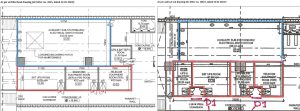
At Pandurangwadi Station, coordination failures between architectural and MEP layouts led to the construction of service rooms based on outdated drawings[1]. This caused misaligned doors, incorrect wall openings, and clashing service routes, which were only discovered after key structural and partition work had already been executed. As a result, demolition and rework were required, delaying MEP installation and impacting the project’s internal handover schedule. This scenario strongly supports the need for an integrated workflow that combines real time reality capture with immersive coordination tools:
1. Reality Capture for Up-to-Date Site Conditions
-
Had biweekly LiDAR or 360° photo scans been used, the project team could have identified deviations between field conditions and latest approved models before commencing installation.
-
This would have created a verified as-built baseline, highlighting inconsistencies between MEP routing and wall layouts.
2. VR Walkthroughs for Pre-Execution Clash Review
-
Using platforms such as Resolve or Cirtual, discipline leads and field engineers could have conducted virtual walkthroughs of the coordinated BIM model.
-
These immersive reviews would have helped spot spatial interferences such as misaligned conduit paths or insufficient clearance for equipment well in advance of physical work.
3. AR Overlays for On-Site Visual Validation
-
Equipping the site team with AR headsets (e.g., HoloLens) would have allowed them to overlay current models directly on site surfaces.
-
This process could have ensured cut-outs, cable trays, and wall openings were installed as per the latest revisions, without relying on potentially outdated 2D drawings.
4. Closed Feedback Loop for Faster Resolution
-
This combined workflow scan, validate, adjust, and execute would have allowed the team to immediately identify and resolve clashes, reducing dependency on manual RFIs and document based communication.
This case illustrates the risks of relying solely on static drawings in complex service zones and the need for immersive coordination tools that reflect real time site conditions. By leveraging scan-to-BIM integration and immersive AR/VR visualization, the project could have prevented costly errors, improved interdisciplinary communication, and maintained schedule alignment thus answering the core research question of this study.
PATTERNS AND SOLUTIONS IDENTIFIED:
| Sr. No | Identified Problem | Solution via AR/VR + Reality Capture |
| 1 | Undetected design changes and mismatches | Laser scans reveal field discrepancies vs design |
| 2 | Late clash identification between trades | VR walk-throughs simulate routing and detect collisions |
| 3 | Miscommunication during coordination meetings | Visual tools bridge gaps across language and technical roles |
| 4 | Errors in confined utility zones | First person AR/VR walkthroughs improve spatial understanding |
OUTCOMES AND RECOMMENDATIONS:
This study demonstrates that integrating AR/VR-enhanced BIM workflows with systematic reality capture transforms traditional coordination practices in rapid rail projects from reactive problem-solving to proactive conflict avoidance.
Key Outcomes
- Clash prevention before construction: Immersive BIM walk-throughs and scan-based model validation enable early detection of spatial conflicts, reducing the risk of unplanned site interventions.
- Reduction in RFIs and rework: Real-time visual validation across disciplines ensures that design changes are understood and implemented uniformly—minimizing coordination delays and costly revisions.
- Enhanced interdisciplinary communication: AR/VR tools provide an intuitive platform for technical and non-technical stakeholders alike, fostering clearer alignment across owner, consultant, and contractor teams.
- Higher installation precision in MEP zones: Field teams use AR overlays to place systems with greater accuracy, reducing cumulative layout errors and the need for manual rework.
- Improved schedule reliability: By resolving design and routing issues prior to execution, project timelines are protected from coordination-related disruptions.
Recommendations for Implementation
- Initiate early-stage reality capture using LiDAR or photogrammetry before partition closures or slab work to establish a verified baseline model.
- Mandate immersive coordination reviews (VR/AR) during milestone BIM checkpoints for critical rooms, shafts, and utility corridors.
- Deploy AR-assisted QA/QC processes on-site to verify field installations against coordinated BIM in real time.
- Schedule recurring reality capture (biweekly or milestone-based) to keep BIM models aligned with as-built conditions.
- Provide focused training and field demos to accelerate adoption and reduce resistance, especially for construction supervisors and trades.
INDUSTRY RELEVANCE AND CONCLUSION
As global transit agencies adopt digital delivery standards, tools like immersive BIM and scan-to-BIM workflows will become central to how projects are coordinated. This case study shows that even in resource constrained or fast track projects, these tools are highly effective in mitigating construction risk.
The research directly supports DBIA’s push for integrated project delivery, and global best practices under ISO 19650. If applied consistently, the coordination model outlined here can become a standard for rapid rail project delivery, driving better safety, efficiency, and cost control.
REFERENCES
[1] Project Observations – Pandurangwadi Station, Mumbai Metro Line 9 (2022–2023). https://mmrda.maharashtra.gov.in/projects/transport/metro-line-9/overview
[2] Lee, Y. J., Kim, H., & Park, J. (2021). Application of AR in Metro Station MEP Coordination. Automation in Construction, 129, 103827. https://www.sciencedirect.com/science/article/abs/pii/S0926580521002788?via%3Dihub
[3] Ma, Z., Zhang, X., & Wang, Y. (2022). Integrating VR with BIM for Infrastructure Projects. Journal of Civil Engineering and Management, 28(4), 280–294. https://www.sciencedirect.com/science/article/pii/S2405844025009387#:~:text=Beyond%20urban%20planning%2C%20BIM%20and,sustainable%20development%20in%20various%20fields.
[4] Autodesk & McKinsey. (2023). The State of Connected Construction. Autodesk Report. https://www.flowforma.com/blog/connected-construction
[5] Interview with John Niles, Senior Consultant – Accenture (May 2025).
[6] Interview with Mayank Jain, Transportation Head – Mumbai Metro Line 9 (May 2025).
MEDIA ATTRIBUTIONS
[1] BIM clash detection diagram – Autodesk Inc. (2023). Sample clash detection model for MEP planning. Used under Fair Use for educational purposes.
Source: https://www.autodesk.com/solutions/bim](https://www.autodesk.com/solutions/bim
[2] Pandurangwadi wall cut-out plan – Project documentation from Mumbai Metro Line 9, GC Systems (2023). Used with internal permission.
Source: Monica Korlepara’s project archive.
[3] LiDAR-generated 3D point-cloud illustration – Image showing a field engineer operating a 3D scanner to capture accurate as-built conditions on a construction site using LiDAR. Used under Fair Use for educational and illustrative purposes. Source: Trimble Inc., 2021. https://geospatial.trimble.com
Media Attributions
- Example of a BIM clash detection model.
- Architectural vs MEP layout mismatch example.
- LiDAR point-cloud scan of a construction site.
About the author

name: Monica Korlepara
Monica Korlepara is a graduate student in Construction Management at the University of Washington with extensive industry experience in India’s metro infrastructure sector. She has held key planning and coordination roles on large-scale projects such as Mumbai Metro Lines 6, 7A, 9, and 4A. As an Assistant Planning Manager at J. Kumar Infraprojects Ltd., she led interdisciplinary teams and collaborated with the MMRDA and consultants to deliver complex urban transit infrastructure. Monica’s core interests lie in digital project delivery, BIM-based coordination, and the integration of AR/VR and reality capture to minimize rework and improve field execution. Her current research focuses on enhancing rapid rail coordination workflows using immersive technologies.
